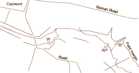
The Troggy runs through the centre of the map (magenta). The Whirly Pools are marked "W". For the sake of identification, the pool on the left (upstream) is denoted the "Upper Whirly Pool", and that on the right (downstream), the "Lower", although these aren't local names. Possible extra resurgences not marked as whirlpools on any official maps are marked "W?". It is likely that there are more of these: local Colin Titcombe mapped a number that were open (even after the capping in the 1800s) in the 1950s to 1970s*. Major roads and the walls of Caerwent are marked in (brown), as are field boundaries (grey) which trips to the field suggest reflect the boundary of the alluvial fill. Distance across the map is ~1km. Dotted line is the position of the current M48 bridge.