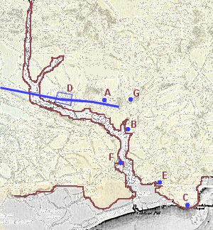
Rough position of early constructions after Dennis Manning's 2004 map from Nettleship*. In order of date: A: Crick round barrow (2000BCE); B: Ditches and cursus (2000BCE?) plus the Berries motte and bailey (1100CE); C: Sudbrook Promonotory Fort (600BCE); D: Caerwent Roman town and road (100CE); E: Harold’s hunting lodge (1065CE); F: Caldicot castle (1100CE) and Bronze age settlement*; G: Crick Manor House or bailey behind it (1200CE). The only difference with the map by Manning is that he uses the 30ft (9.1m) contour as the reference outline, and here we use the rough alluvium location1.